traditional survey - Land Survey

Land Survey

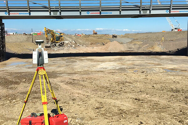
Despite the introduction of survey drones, traditional land surveys (or topographical surveys) still play a leading role in our services for clients. This service is most useful when a drone is not able to support activities due to restrictions such as controlled airspaces and dense vegetation. It is very useful for projects such as pre-construction planning, small, short-term construction projects and general land surveys to provide comprehensive clarity and reduce the risk of potentially expensive latent errors.

We use Leica Geo Systems Total Stations and GNSS survey equipment to provide clients with high quality, accurate deliverables that can be provided in many different formats.

Land Survey Services

Skymatics Spinning

Land Survey

We use the latest technology including terrestrial scanners, GNSS systems, drones and robotic total stations to provide accurate and cost-effective topographical surveys.

Skymatics Spinning

Site Engineering & Setting Out

From understanding drawings, setting out foundations, steel frames, services, monitoring, as-built surveys, earthworks and volume calculations we can provide the complete solution.

Skymatics Spinning

Digital Terrain Modelling

We work across multiple software platforms so we can produce a selection of different outputs and formats to suit varying client requirements.

Skymatics Spinning

Volume Analysis & Reporting

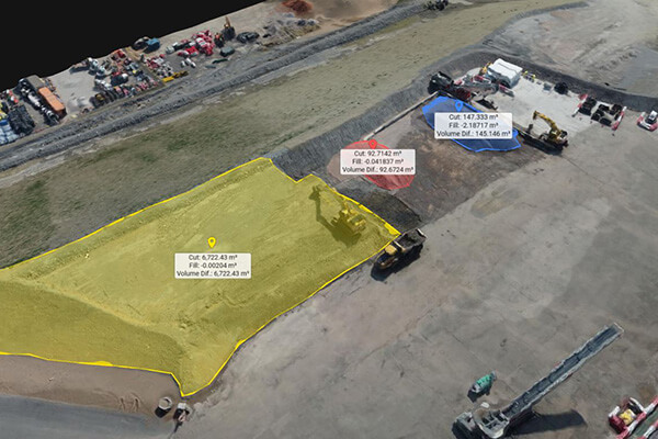
Making sure that every ton of material moved on your project is accounted for. This is essential to understanding the efficiency of your project and ultimately financially benefiting both the client and contractor.

traditional survey topographical survey - Land Survey

Land Survey

At Skymatics we have the expertise and experience to provide accurate results every time, on time and in budget. We accumulate survey information about the natural and man-made characteristics of the land and its features. Employing proven methods, experienced operatives and utilising the latest technology we acquire information through detailed studies and measurements in the field, to conduct thorough data analysis and valuable land surveying results.

  • Topographical surveys
  • Boundaries surveys
  • Building area surveys
  • Land partitions
  • Easement surveys
  • Road layout surveys
  • Construction layouts
  • Unit surveys
  • UAV or drone mapping
traditional survey site engineering setting out - Land Survey

Site Engineering & Setting Out

Site engineering and setting out is one of the first and final steps  in many projects before the physical project can be completed. From setting out the building footprint for enabling earthworks to setting pins for the surface course asphalt to be laid to.

Our engineering team use the latest technology in geosystems to achieve precise results combined with a wealth of experience to ensure a robust methodology is used in each operation.

We accurately mark out details to provide the site team with as much information as possible, extracting the design from specifications, drawings and correspondence.

We work with data in multiple formats, importing 2d and 3d  substructure items such as services, drainage and foundations and exporting as built information to quality assure our work.

traditional survey digital terrain modelling - Land Survey

Digital Terrain Modelling

Our CAD software will produce a triangulated digital terrain model (DTM). This triangular mesh is the foundation of all the modelling we do. Any data, observations, surveys or design information imported into our software is modelled. We can then choose to display contours at any interval. The triangles and contours are dynamic and react instantly to changes to the points that make up the DTM. If the data from which the DTM was created contained feature codes (lines and coded points) then these can be set to be inside the DTM or not.

Alongside general DTM creation, we can aslo report volumes, design excavations, earthworks profiles, calculate level differences and more.

traditional survey volume analysis - Land Survey

Volume Analysis & Reporting

After completing comprehensive volume analysis you can utilise our reports in negotiating bids, settling engineering issues and verifying cost estimates.

We  often complete the following considerations when completing our volume analysis and reporting.

  • Demolition
  • Topsoil Strip
  • Strata Layers
  • Over-excavation and Back Fill
  • Structural Fill
  • Bulk Excavation

Volumes can be sub-categorized and broken down out for building pads, paving surfaces, ponds, and general landscaping to define varying material types such as structural and non structural fills. They can also be customized as per your directions to meet your specific needs.